World Karst Museum is on Pracimantoro

One of them by building a museum in the world karst Gebangharjo Pracimantoro Wonogiri. Sewu mountain karst region is stretched between the shore Parangtritis, in Bantul District until the district Pacitan Pacitan bay.
However, an administrative region in Wonogiri district is located in most districts Paranggupito, Giritontro, Pracimantoro, Giriwoyo and sub Eromoko.
Extensive karst region of about 18.6% of the area of natural Wonogiri.Bentang karst district in the district of Wonogiri prepared by different wake-origin involving the dissolution of limestone.
Symptoms of dissolution or better known as the karstifikasi was developed on the surface (eksokarst) and subsurface (endokarst).
In karst areas can be found in the Karren, conical hills, sinusoid, embankment, pepino, doplina, Uvala, Polje, ponds, dry river valley ancient Solo, ponora, caves and others.
Karren or dissolution there is a wake-layer hollow, hollow, grooved, bersaluran, and so forth.
While the separate hills berbangun cone or have a curved surface (sinuosida) which was situated adjacent to each other.
Each groove indivisdu hills interspersed by topography or terrain of mutual bersambungan.Proses karstifikasi during geological time and space
will then form a stretch of thousands of hill cone (conical hills), which became the main characteristic of the karst mountain areas Sewu.
On Tuesday, June 17, 2008, yesterday, me and seven of my friends got an honor to become an ambassador or a participant socialization Mount Sewu Kars region, held at Studio Wonogiri Learning Activities.
We were accompanied by three people guru.Peserta socialization totaling 100 people, 75% of all high school students dalah Wonogiri and the rest are assistant teachers.
We get a wide range of facilities from the government Wonogiri. Among these are blocks of notes, hand outs, hats, shirts, transport allowance and money
saku.Selain that, we also obtain lodging facilities in the hostel Studio Learning Activities.
We feel happy to menikmatinya.Sosialisasi this is a form of cooperation from the government district
Wonogiri Environmental Office Forestry and Mines with one private university in Surakarta, the Muhammadiyah University of Surakarta (UMS).
The purpose of this event is held to introduce this karst region to students and teachers for science menambahwawasan for us.
Dissemination activities opened by the Regent Wonogiri who was unable to attend and eventually delegated to the staff assistant kerjanya.Pemberian material pertamaatau first season by Drs.H.Kuswaji D. Priyono, M. Si, which is the teaching staff of Geomorphology
Faculty UMS.Beliau menjelaskadefinisi geography karst, karst museum, the potential of different materials from the area in the region of Kars Mountain Sewu Wonogiri.
The term karst is derived from the karst of the Slavic countries, which means rock. Next karst region is used as a term for limestone and dolomite that have a unique landscape with cirri as a result of the leaching process.
In addition, he also explained on the basis of the analysis, either by the system or system 5W +1 H SWOT.Berbagai kinds of images and photographs are very beautiful and attractive are introduced to us through the LCD screen, among other throne found in the cave, the phenomenon of caves, under waterfalls land, valley Solo Ancient, lake that began to dry up and so forth.
We were very surprised at the result of Allah's creation. The main land by a genetic form, namely the origin of land forms the structural, volcanic, denudational, fluvial, marine, solutional, eolian, and organic. Landform solutional or karst topography include dome karst, karst hills, remnant karst hills, Uvala, Ledok karst topography and dolina.Dolina is a terrletak groove between limestone hills, with a rounded building or lonjong.Lekuk Dolina generally closed and has a line was started a few meters to more ddari 30 meter.Setempat closed curves is limited by the steep limestone walls, as high as tens of meters.
Until now there are about 15 laws and regulations related to the development of karst areas, ranging Law No.11/1967 on the principal provisions of the mining until the decision of the Minister of Energy and Mineral Resources No.1456/2000 of guidelines clarifying procedures for karst areas.
However, the question why in fact damage karst areas in Indonesia is increasingly meluas.Faktor whether that influence?
In the question and answer forum and quite a lot of questions raised by the teachers and only a few students who bertanya.Acara is quite interesting. Season both delivered by Suharjo father who is also a professor of geography faculty UMS.Beliau describes the geomorphology Wonogiri Kars region by displaying pictures limestone mountains. In addition, he also describes the process geomorphology, landform regions Wonogiri, a tool for the study of geomorphology, karst formation conditions, and potential land resources alam.Bentuk Wonogiri area is generally a structural formation plateau region.
In the northern part is the hilly Baturagung and in the south, karst.Pada topographic landform of this forum also held question and answer this menarik.Acara enough took place at 13:00 to 14:30 WIB.Setelah event was the third ISHOMA.Season submitted by members KMPA Giri Bahamas from the faculty of Geography, UMS.Mereka explain the tools needed in the search caves or caving and climbing tebing.Selain, they play a documentary film about the search and search caves underground water sources in karst region tersebut.Ada feelings of awe, wonder, at the same time horror, saw the struggle of the student when entering luweng a depth of more than 100 meters.
With a very high risk, they still remain rigid carry out these activities in order to get water with a very high spirit of devotion, the spirit of nationalism which was great to find the source of water for surrounding communities luweng that every dry season comes, always short of water.
For students who have the adventurous spirit is high, are not directly motivated to do activities petualangan.Sampai-up to our school, SMA Negeri 1 Baturetno who have extra-curricular activities of nature lovers to expect the presence of mas Joko Sulistyo and friends, to guide and direct these activities . Actually, I hope the documentary is not just for the documentation of the UMS saja.Tujuannya for students who have not watched the show the movie can be interested in studying geography subjects in khusus.Namun unfortunately, my request is not fulfilled or can not be granted reason have not registered with right ciptanya.Akhirnya, I and other participants can understand those reasons.
On the second day, we were taken to the karst region is to see directly, which is located in the district Pracimantoro.Perjalanan we use a fleet of buses with the sequence number of SMA Negeri 1 tiga.Kami Baturetno Pangudi sit side by side with high school is very exciting Luhur Giriwoyo.Perjalanan .
Kamidipandu by one student who called Joko Sulistyo.Saya notes about things that have been explained by the student. We also arrived at the rest of calcite mines located in the hamlet of Pule, Gedong village, subdistrict Pracimantoro.Pertambangan done in this place is wrong and harmful to the environment alam.Salah one handling the damage this area is to be held reklamasi.Reklamasi is an effort to restore land mining to agriculture by way of flattened land.
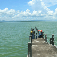
There also can be found in the factory calcite. The next trip is to the Ancient Solo River valley area of land now used for field planting crops, especially cassava pohon.Di this area, we did not find any settlements due to the relatively sepi.Lembah area is located approximately 1 mile to the beach Sadeng. dry valley more than 21 km in length that twist and form a straightness in a particular direction.
One luweng can be found here, but it is closed with a stone for the land does not go in and let only water that seeped into the ground tersebut.Contour which can be seen, Solo Ancient flanked by two hills and stretching to the north-selatan.Mula first straight longitudinal valley to the south, then turned to the southwest to west. Then, suddenly turned again to the south, then to the southeast and finally to the southwest before it empties into the beach sadeng.dinding 20-75 meter high valley has a steep slope, an average of more than 60. Its width ranges from 40 - 100 meters.
At eksokarst be symptoms not related to the process of reversing the flow direction in the days of ancient Solo quarter as expected by experts sebelumnya.Setelah entire southern basin pegunungn raised at the beginning of the quarter, on the surface of limestone in the area Wonogiri now flows a river that tipped surface in the northern mountain Sewu and empties into the Indian Ocean. In some dry valley walls can be found a short perguaan system, or niche, which is located opposite (side one). In the caves that can be found any artifacts or pieces of bone and shell clams vertebrates that alleged human leftovers prasaejarah. circumstances underlying assumption that if the caves along the dry valley Giritontro a cave archaeological site, once a prehistoric human huniaan or stopover.
My question is why the flow of the Ancient Solo is now experiencing a change? We continue the journey to the source of lime to the soil surface water
creek that started this mengering.Telaga covered terra rossa soil. The explanation that we can but it is the effect arising from the provision of cement to the lake tersebut.Itu due to contact between the chemicals making up cement with limestone in
tersebut.Sehingga area there was water coming into it. Vegetation endemic karst include teak and fruit trees .. Sweet sugar apple fruits whether or not it was influenced by the presence of moisture in the soil that plants sendiri.Setiap available, can be used as a pointer location presence of water or more commonly known as associates. For example banyan that could give clues to the location of many water cave and also the mouth of the cave.
Travel remains among the entourage berlanjut.Banyak lelah.Namun bus, we remain eager to berpetualang.Kami arrived at this dunia.Wilayah karst region consists of seven caves consisting of translucent cave, cave Mrico, Sodong cave, cave Sapen, Bunder Potro cave, caves and cave Sonyaruri sheen. Each cave, is named in line with expectations and spiritual behavior of visitors visited the cave in the cave lalu.Kami lustrous, translucent cave, cave Sodong, Mrico cave. Actually, I wanted to go to another cave, but a limited time.
Lustrous Cave is located approximately 300 meters from the highway, located on the hillside bawah.Saat parts will go to this cave, we see this area used as a dumping ground is less savory sampah.Fenomena dipandang.Seharusnya, this tourist area free from scattered scattered garbage and reducing the stinging smell of beauty which is also located stalagtit.Selain alam.Gua, the silhouette cave lustrous matahari.Stalagtit opposite direction of existing radiation, turning toward the sun because the hole is covered by mineral deposits that memnbentuk hole timur.Bagi new direction this cave crawler, to find out the situation time of day or night by using this alami.Jam hours due to the turn of the cave dwellers of Swallow bird with kelelawar.Bila time of day, is a bat cave dwellers, and if the bird Swallow entered into
cave, bats out that means time muli malam.Namun still unfortunate circumstances which have beautiful stained with the graffiti-graffiti hand.
The cave penetrating is one cave that was stated by President Susilo Bambang Yudhoyono, 6 December 2004. The cave is beautiful, adorned with stalactites and stalagmites. In some cavities in the walls of the cave looks increasingly dim lighting add to the exotic caves .. In entering this cave, we see the rules posted on the walls of the cave. One is we should not throw garbage in sana.Yang into the base or the floor is sand that comes from Nampu. After we walked out, we found a stopover derived from rice straw roofs.
The location of the next tourist attraction is a cave cave sodong.Keunikan Sodong than the other cave is a bit basah.Gua roof is the result of dissolution of limestone rocks and atmosphere seen in it the dark without a penerangan.Di here can also be found in water sources used people around for washing and bathing.
Cave Mrica small shape, slightly rounded like pepper and vegetation found in this cave awar.Pada awar-way dead end and found the former constituent terpotong.Materi stalactite cave that this is the calcite crystals.
In the vicinity of the cave was used as a museum of karst world which was originally to be opened by President Susilo Bambang Yudhoyono.Namun, until now has not been done and the builders will begin in the near future.
At this location socialization activities terminated. Many of the impression and the message we rasakan.Di whom are we happy with events like our ini.Wawasan grow and can compare between the theories that have been submitted by visits in the field.

Comments